They say the best things in life are free, and now GPS-powered navigation can be added to that list, thanks to smartphone apps. While there are plenty of paid smartphone nav apps, a few are absolutely free for the download. We wanted to see how they stack up against the paid apps we tested last year.
While not as full-featured as paid apps, we found that the free nav apps can ably get you from Point A to Point B and also provide a few additional benefits. And although some are also available for Android and BlackBerry smartphones, we focused on the iPhone platform, given the popularity of the device and its plethora of apps — more than 200,000 and counting. The four free iPhone GPS navigation apps we tested are compatible with the iPhone 3G, 3GS and iPad, and all but one (Skobbler) also work with the iPod Touch via a WiFi connection.
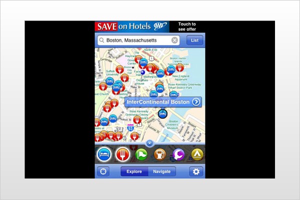
AAA TripTik
Grade: A
Pros: Intuitive main screen, reliable voice prompts, quick route recalculation
Cons: Needs a more robust points-of-interest database
Size: 7.4MB
AAA has been a trusted driving-directions resource for decades, so it's only natural that the organization would repurpose its time-honored TripTik travel planner for the iPhone. A well-designed main screen allows you to expand and reduce selectable categories of points of interest (POI), including hotels, restaurants and gas stations. There's also the ability to check and compare gas prices and get AAA-rated restaurant reviews and then call for reservations with the tap of a button. Overall, the POI database could be much more robust (it couldn't locate a prominent regional park), but the pluses outweigh the minuses.
Both a turn list and map view are available on the main screen to detail your desired route with both text and map-based directions, and the app delivered quick route recalculations. Voice guidance was accurate and easy to understand, and you can zoom in to your position on the map by tapping an icon or simply shaking the iPhone. We also really liked a feature that lets you toggle between the Directions and Map view to either check your progress on the map or review a list view of directions.
Two shortcut buttons we frequently relied on that have great utility are the Explore and Navigate buttons on the home screen. Navigate cuts straight to the routing menu, while Explore lets you call up POIs and quickly set a course to them. AAA members will also like the fact that if you require vehicle assistance, the app lets you alert the Auto Club to your exact location, vehicle type and status.
MapQuest4Mobile
Grade: A+
Pros: Abundant POI categories and entries, can save routes, pedestrian mode
Cons: No 3D view
Size: 4.2MB
We found ourselves thinking the AAA and MapQuest app developers were looking over each other's shoulders, as some design elements and functionalities (i.e., toggling POIs and side-scrolling route information) are identical. There are definitely some unique elements here, though.
For starters, there's the map data itself, which is the MapQuest many know very well. Navigation is also made efficient via the Map or List tabs on top of the main screen, so you can quickly follow a route by the map or a turn list. Then there's the POI carousel scrolling, giving you 10 categories to display, the ability to add more POIs from the database and the option to search your iPhone's contact database for addresses to which you want to navigate. It also has a pedestrian mode.
On our wish list for the next version is a north-up orientation instead of only a heading-up view. But props are in order for easy-to-understand voice guidance that gives you an alert with plenty of time for the maneuver. We also liked the handy "My Places" section that lets you save routes and maps.
Another plus in the settings is something you'll find in most paid apps: the ability to calculate your routes by shortest distance, shortest time and avoidance of highways or toll roads. There's a playful element here, too: You're given abundant choices for your icon, including car, battleship, cat, footprint or UFO. You also can upload your own icons.
Skobbler
Grade: B+
Pros: Useful manual, excellent voice prompts, integrates iPhone contacts and music
Cons: Data-entry quirks, erratic zooming
Size: 2.3MB
Skobbler takes a very different tack by going the open-source "wiki" route. The map data uses the OpenStreetMap platform, and Skobbler encourages users to update and improve the map by reporting bugs like bad routing and missing streets. Overachieving types can even edit and enhance the map using the OSM editor that's available online. The app also includes an informative manual that includes tips, such as "use a car charger; the GPS performance of your mobile phone decreases with lower battery."
On the road, Skobbler performed well. You're greeted not by a map, but by an info screen giving you the option to search for an address or "Take Me Home" to get a saved address. We also appreciated the clear, non-robotic voice prompts, visual turn guidance and oversized toggling icons that let you do things like access your music files, get concise trip-information updates (including your current position) and select a day or night screen.
Reporting a bug is simple: One tap gets you to a menu of options such as "bad routing" or "blocked street." On the downside, there are some quirks that can prove a little annoying while you're learning the app. When you're entering an address, it's best to just partially input it ("Wilsh" for Wilshire Boulevard, for example) and then enter a city or a ZIP code at the City/ZIP prompt — but not both. Otherwise, you may get an error message. We also found the "pinch" zoom feature somewhat erratic.
Waze
Grade: A-
Pros: Integrates iPhone contacts, smart-route recalculation, good zooming feature
Cons: Database needs updating
Size: 7.9MB
A self-described "social navigation app," Waze relies entirely on community to build and confirm maps based on U.S. government map data. That's both the app's advantage and its disadvantage. The upside is that Waze brings together engaged users who, just by driving, confirm routes and help Waze track traffic and speed patterns. More proactive users can also provide real-time updates to other drivers, alerting them to everything from speed traps to fender benders using a Report icon.
The downside is that until the app reaches critical mass, there will be information gaps. But Waze approaches the opportunity to build a community of users with a sense of humor. The company's Pac-Man-like icon appears when you're navigating a road that has never been driven by another user, and it gobbles dots that earn points. In fact, the entire interface has a gamelike quality, including the ability to change the mood of your driver ID to "cool" "happy" or "mad" and gobble "Easter eggs" for bonus points. (During the World Cup, those icons were soccer balls.)
The real social cachet of Waze is the ability to see icons of other nearby "Wazers," ping them and even send images of current traffic conditions. When opening the app, you're greeted by the map and multiple options, including confirming your location, drive to a destination and the ability to report to the Waze community. An exclamation icon lists recently reported events like accidents and traffic, while a click on the Star icon lets you know how many points you've earned.