VIDEO: Low-Priced Portable Navigation Systems
Just a few years ago, portable navigation systems were flying off store shelves. But that was before everything from beaters to BMWs had them hanging from their windshields and phone-based nav applications began to become a popular alternative. This sales downturn came about just as the priciest portables started to provide advanced features such as Internet-connected search, live traffic updates and Bluetooth hands-free capabilities.
While few are willing to drop big bucks on high-end portable navs these days, there's never been a better time to buy a bargain unit, especially since some of the latest technologies have trickled down to more affordable portables. To help you decide which one to buy, we rounded up four portables priced under $200 and road-tested them to see what they're packing.
Almost always smaller in form factor and less feature-filled than their more blingy brethren, these bargain portable navs still proved to be highly effective road warriors precisely because of their smaller profile and no-nonsense interfaces. And as we discovered, good things really do come in small packages.
Back to top
Back to top
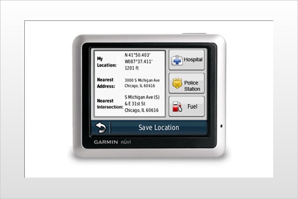
Garmin Nuvi 1200
MSRP: $149
Dimensions: Screen: 3.5 inches; Unit: 3.7-by-2.9-by-0.6 inches
Weight: 4 ounces
Map: U.S. and Puerto Rico
Pros: Strong graphics; innovative features
Cons: Clumsy keyboard; no lane assist
Overall Grade: B
Garmin brings years of legacy technology and expertise to the category of entry-level portable nav systems and it shows in the Nuvi 1200. Compact with a 3.5 touchscreen, the unit still feels substantial and looks stylish, with a bezeled silver-toned faceplate. Under the hood, its feature set also delivers substantial utility.
For starters, we liked the two oversize icons that greet you on the main screen — "Where To?" and "View Map" — and get you ready to roll. (A submenu also lets you access "Volume and Tools.") Another feature we liked was the "Where Am I" screen. No fumbling for information: Just tap the onscreen location cursor/car icon to get your location, as well as info on the nearest emergency services and gas stations.
An innovative addition is the ecoRoute function, a multifeatured way to check your fuel-efficiency and carbon footprint while the unit is in map view. Just set your vehicle's city and highway fuel-economy ratings and the Nuvi 1200 will calculate how your car is performing by giving summaries and graphs of the overall score on braking and acceleration, fuel-per-mile costs and your carbon footprint.
On the downside, the Nuvi 1200's keyboard interface was sometimes unresponsive and didn't offer a choice between a Qwerty and ABC layout like other units. It also didn't provide lane guidance to help a driver negotiate tricky intersections.
Motonav TN20
MSRP: $179.99
Dimensions: Screen: 3.5 inches; Unit: 3.7-by-3.2-by-0.7 inches
Weight: 5 ounces
Maps: U.S.
Pros: Lane guidance; Route Preview mode
Cons: Spare graphics; voice prompts marred by odd pronunciation
Overall Grade: B-
Portable nav is relatively new terrain for consumer electronics giant Motorola. So it's no surprise that the company is still on the learning curve, which shows in elements of the Motonav TN20. These include an overall design that's boxy and unremarkable, bare-bones graphics and text-to-speech (TTS) voice prompts that are in dire need of a diction lesson. The POI database is also sparse: It couldn't find local bars and restaurants that have been in a Los Angeles neighborhood for more than a year.
That's not to say there aren't some bright spots, such as lane guidance, which is a rarity in low-price units. Other pluses include a Route Preview mode that simulates your chosen route and a straight-no-chaser home screen with three icons: "Go," "Map" and "Settings."
After creating a route, the map-view user interface effectively packs a lot of data into a route-status bar, displaying essential info such as distance, time to destination and direction. The screen also includes gray-scaled icons for 2D and 3D views, an option to create a new routing start point and volume control.
The Settings menu is also an impressive three screens deep and allows you to select things like a GPS signal strength indicator, keyboard setting control (Qwerty or ABC), and POI map icons such as gas stations and ATMs. If only you could always understand what it was saying when it gave you directions.
Magellan RoadMate 1470
MSRP: $199.99
Dimensions: Screen: 4.7 inches: Unit: 3.3-by-5.2-by-0.7 inches
Weight: 6 ounces
Maps: U.S., Canada, Puerto Rico
Pros: Lane guidance; One Touch mode
Cons: No pedestrian mode; most expensive unit tested
Overall Grade: A-
Just squeaking in under the $200 price point, the RoadMate 1470 might be the most expensive unit in the test, but it's also the clear standout. This is due not only to its 4.7-inch touchscreen with 480-by-272 resolution, but also because of its overachieving feature set.
Examples include detailed lane guidance, a vast POI database and the user-friendly One Touch mode that puts a customizable cache of locations and saved searches such as "Home," "Previous Destination" and "ATM/Bank" one tap away. You can also use this feature to configure your own favorite destinations, with up to 15 on two screen views.
Routing is made more dynamic by the ability to create and optimize new segments on the fly, with options such as "Fastest," "Shortest," "Mostly Freeways" and "Least Use of Freeways." And touching a Map icon will give you all the options mapped out in color-coded clarity. Typical of the UI, once you have created a route, you get an oversize orange "Go" button for easy input. After getting you to your destination, the RoadMate gets extra points for offering a "Find Parking" option, which displays multiple parking choices.
The RoadMate 1470 is the most expensive unit we tested and the second heaviest (by 0.1 ounce). Plus, it doesn't have a pedestrian mode or, unlike the TomTom unit, innovative features like the ability to change the TTS voice.
TomTom Ease
MSRP: $119.95
Dimensions: Screen: 3.5 inches; Unit: 3.4-by-3.6-by-1.2 inches
Weight: 6.1 ounces
Pros: Lowest-priced; quickly scalable map views
Cons: No lane guidance; inconvenient volume control
Maps: U.S.
Overall Grade: A-
With a compact size, clean graphics and maps and a robust POI database, the recently released TomTom Ease certainly lives up to its name. Beginning with the main screen, TomTom manages to get all the important icons in one easily navigable location, while keeping the UI tidy and efficient. The oversize main menu buttons display just two options, "Plan Route" and "Browse Map," while a submenu features other essentials like day/night and 2D/3D settings, "Help" (which gives your location and emergency services contacts), a mute button and "Options."
Under "Options," the choices are substantial for an entry-level device. Users can choose from multiple TTS voices (with the best pronunciation of any unit we tested), the option to customize everything from Day and Night map color schemes to your car icon and access to TomTom's MapShare community to receive mapping updates generated by other users.
We also liked the ability to quickly scale the map view with a screen-right slider and the one-touch "You Are Here" arrow. Creating an active route gives you a screen that includes a user-friendly route status bar that toggles between info such as speed and volume, distance to destination, time to destination, a route overview and the ability to change your route.
The Ease also incorporates TomTom's IQ Routes technology, which uses actual average speeds on roads instead of posted limits to configure your fastest possible routes. And we found the battery life to be best of breed. But the Ease doesn't have lane guidance, and a volume control that's buried behind the speed icon in the route-status bar is counterintuitive and inconvenient.