Since Google Maps took the world by storm a few years ago, this offshoot of Google has become even more user-friendly and its satellite images even more accurate. New features like Street View and mash-ups, which overlay written and visual information onto Google Maps, offer practical applications for drivers everywhere.
Millions of people have taken virtual joy rides using Google Maps or Google Earth without knowing the difference between them. Both applications employ seamlessly meshed satellite images superimposed over Google's digital mapping system to give users the thrill of having the whole world at their fingertips. Contrary to urban legend, none of the imagery is available in real time, but dates back from one to three years ago. While Google Earth involves downloading an application to your computer, Google Maps is available immediately via the Internet.
Many Web communities and blogs have emerged to keep track of the new features introduced since Google Maps' inception. Google Maps Mania, launched by Mike Pegg in 2005, covers Google-based tools as well as fun and practical applications created by people all over the world.
"We're destined to see big things from this, both as the maps improve and as people's imaginations continue to go wild with them," Pegg said to National Public Radio in 2006. His enthusiasm continues today.
"Google Maps and mash-ups have transformed the ways people research their travel activities and look for places to live," he said. "The mapping data is improving as well, with more updated imagery being added to Google Maps each month."
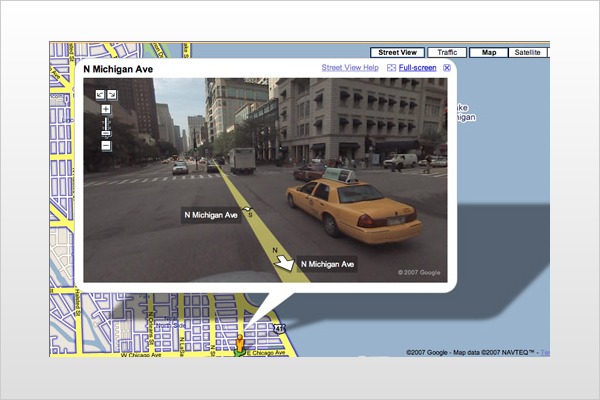
Other sites, like Google Sightseeing and Virtual Globetrotting, chronicle updates in the satellite imagery and report on quirky details caught in those images. Streetviewr keeps track of interesting or embarrassing moments captured in Street View. Incorporated into Google Maps earlier this year, Street View links from designated map locations to street-level photos, simulating 360-degree views of major thoroughfares in an ever-growing number of U.S. cities.
Eavesdropping on the far corners of the world from the privacy of your own monitor may be great entertainment, but Street View and other Google Maps features have practical uses, too. For instance, zooming in on Street View photos makes it easy to read parking restriction signs or to spot intersections that have left turn lanes. Google Maps has always provided driving directions with the option of including multiple stops. Now, it offers a "drag-and-drop" feature to customize trips. By clicking on the highlighted route and dragging it to locations you prefer, you automatically update the directions. Google Maps also features live traffic conditions for select cities, even including information about both directions of traffic on interstate highways.
Mash-ups — Web sites created independently of Google that embellish Google Maps with annotations, photos and interactive content — open up a whole new world. Pegg explained that "mash-up," a term used in the music industry for remixing songs together into new musical combinations, applies to Google Maps applications, too.
"You're taking the map and the data and mashing it up together," Pegg said. "The many mapping innovations that Google has introduced have turned lots of people into mash-up creators — not just folks with technical backgrounds but people with no programming skills who can create a Google mash-up in minutes on the Web using Google's map creation tools."
Once a mash-up is launched online, many mash-up creators invite users to add information to their mash-ups, accumulating helpful facts at a local or national level. Gas Buddy, for example, posts gas prices directly onto a searchable map. Weather Bonk accesses weather conditions through a map and syncs forecasts with driving directions. At RoadPetition, drivers can target road conditions that are hazardous or annoying (such as potholes) and get a petition started to fix the problem. More information about such sites is available through Google Maps Mania and Cool Google Maps.
Travelers can learn about local customs and taboos by clicking on vacation destinations at Travel Dodo. Clickable maps with information about restaurants, clubs and sports events are available online for large cities in the country. Other sites cater to more idiosyncratic tastes, like Dark Destinations or Roadside America, which pinpoint offbeat tourist attractions around the country.
Google Maps also provides information on traffic jams. Cities from Boston to San Francisco are digitally mapping their transit systems. Google Maps has recently added an option within its driving directions function that offers public transit information and is testing a ride finder portal, currently with taxi and shuttle information for several cities. RideShare.us uses Google Maps to help commuters and event planners reduce roadway and parking congestion by establishing carpools.
Mobile devices allow you to take Google Maps along for the drive. On its site, Google explains how to access Google Maps with cell phones or portable digital assistants or how to use them to enhance GPS data. Before hitting the road, mobile phone users can check SignalMap to search for cell phone coverage, locate dead spots and compare signal strengths at various locations.
Mercedes-Benz drivers with the TeleAid driver assistance system can even send Google Map searches to their car's navigation system using the recently introduced Search & Send function. And if a Benz driver forgets to download the map before they get on the road, they can ask anyone at a computer to transmit it remotely. Mercedes-Benz is the only company that offers this feature in the United States, though a similar service is available from BMW in Germany.
With so many creative uses of Google Maps out there, you may be inspired to put the Web site to the test. Use Street View to plan a scenic drive or to decide whether that sidewalk café really has romantic ambience. Drag and drop to plot the shortest route to work. Find a mash-up to help you remember the name of the terrific hotel you stayed at on your last vacation. Edmunds recently set up the Stupid Google Tricks discussion on CarSpace to share wacky or practical ways drivers use Google Maps or Google Earth. From repair shops to alternative-fuel stations, from classic car rallies to rest stop locations, Google Maps can bring the automotive world to your door.